India has a total area of 3,287,263 sq km. The north of the country
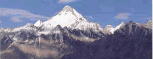
is decisively bordered by the long sweep of the Himalaya, the highest mountains
on earth. They run from south-east to north-west, separating India from China.
Bhutan in the east and Nepal in the centre actually lie along the Himalaya,
as does Sikkim, Darjeeling, the northern part of Uttar Pradesh, Himachal
Pradesh and sJammu & Kashmir.
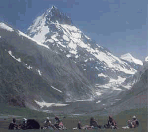
The Himalaya are not a single mountain range but a series of ranges
with beautiful valleys wedged between them. The Kullu Valley in Himachal
Pradesh and the Vale of Kashmir in Jammu & Kashmir are both Himalayan
valleys, as is the Kathmandu Valley in Nepal. Kanchenjunga (8598 metres)
is the highest mountain in India, although until Sikkim (and Kanchenjunga)
were absorbed into India that honour went to Nanda Devi (7817 metres). Beyond
the Himalaya stretches the high, dry and barren Tibelan plateau; in Ladakh,
a small part of this plateau actually lies within India's boundaries.
The final southern range of the Himalaya, the Siwalik Hills, ends abruptly
in the great northern plains of India. In complete contrast to the soaring
mountain peaks, the northern plain is oppressively flat and slopes so grad-
ually that all the way from Delhi to the Bay of Bengal it drops only 200
metres. The mighty Ganges River, which has its source in the Himalaya, drains
a large part of the northern plain and is the major river in India. The
Brahmaputra, flowing from the north- east of the country, is the other major
river of the north. In the north-west, the Indus River starts flowing through
Ladakh in India but soon diverts into Pakistan to become that country's most
important river.
|
South of the northern plains, the land rises up into the high plateau
known as the Deccan. The Deccan plateau is bordered on both sides by ranges
of hills which parallel the coast to the east and west. The Western Gnats
are higher and have a wider coastal strip than the Eastern Ghats. The two
ranges meet in the extreme south in the Nilgiri Hills. The southern hill
stations are in these hills: Matheran and Mahabaleshwar, near Bombay in the
Western Ghats; Ooty and Kodaikanal in the Nilgiri Hills. The major rivers
of the south are the Godavari and the Krishna. Both rise on the eastern slope
of the Western Ghats and flow across the Deccan into the sea on the eastern
coast.
The north-eastern boundary of India is also defined by the foothills
of the Himalaya, which separate the country from Myanmar (Burma). In this
region, India bends almost entirely around Bangladesh, a low-lying country
at the delta of the Ganges and Brahmaputra, and almost meets the sea on the
eastern side.
On the western side, India is separated from Pakistan by three distinct
regions. In the north, in the disputed area of Kashmir, the Himalaya forms
the boundary between the two countries. The Himalaya drop down to the plains
of the Punjab, which then merge into the Great Thar Desert in the western
part ofRajasthan. This is an area of great natural beauty and extreme barrenness.
Finally, the Indian state of Gujarat is separated from the Sind in Pakistan
by the unusual marshland known as the Rann of Kutch. In the dry season, the
Rann dries out, leaving isolated slat islandon an expansive plain: in the
west season, it floods to become a vast island sea.
|